
MAP OF THE NETHERLANDS
MAP OF THE NETHERLANDS. ZATTA, ANTONIO. Le Provincie di Zelanda, Utrecht, Gheldria, e. wear.
- 2017-10-15 00:00:00
- Stockholms Auktionsverk
- Länk till objektet
Slutpris:400 SEK
Avslutade auktioner liknande MAP OF THE NETHERLANDS

Map of the Netherlands 1802
THE NETHERLANDS. Netherlands, Repubblica Batava, Charles Francois Delamarche - La Republique Batave divisée en ses departmens. Venise, 1802. Centrefold as issued, some creases, some tears Läs mer...
- 2021-05-03
- Stockholms Auktionsverk
- 350 SEK

Atlas the Netherlands Fricx 1712
ATLAS OF THE NETHERLANDS. FRICX, Eugène-Henri. Table des cartes des Pays Bas et des frontieres de France [...]. Brussels 1712. Not complete. All maps partly Läs mer...
- 2021-03-21
- Stockholms Auktionsverk
- 3 000 SEK

Karta över Norden
Vägghängd karta över Norden. Kartografi, reproduktion & tryck Dr. Magnus Roth Mått: 210 x 155 cm Konditionsrapport: Märken, revor & bruksslitage, veck, inga övriga anmärkningar. Läs mer...
- 2022-12-01
- Norrlands Auktionsverk
- 550 SEK

Three maps of The Netherlands and South America
MAPS, (3), all published by LAURIE & WHITTLE, London:. All with central folding marks and margin tears to the fold. A new map of the Läs mer...
- 2019-03-11
- Stockholms Auktionsverk
- 1 400 SEK

Anson map of South America
MAP OF SOUTH AMERICA . ANSON, GEORGE. A chart of the southern part of South America : with the track of the Centurion from the Läs mer...
- 2020-09-20
- Stockholms Auktionsverk
- 2 400 SEK
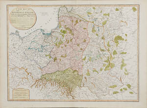
Map of Poland 1799
MAP OF POLAND. A New Map Of The Kingdom of Poland with its Dismembered Provinces and the Kingdom of Prussia, London, Laurie & Whittle, 1799. Läs mer...
- 2020-09-20
- Stockholms Auktionsverk
- 1 600 SEK
![Atlas J.B.H. Chauchard A General Map of the Empire of Germany, Holland, the Netherlands, Switzerland, the Grisons, Italy, Sicily [...].](https://img.bruun-rasmussen.dk/g/BRFull/Arkiv/Online/1348/br_1339561_300x300.jpg)
Atlas: J.B.H. Chauchard: A General Map of the Empi...
J.B.H. Chauchard: A General Map of the Empire of Germany, Holland, the Netherlands, Switzerland, the Grisons, Italy, Sicily, Corsica, and Sardinia. London: John Stockdale [no Läs mer...
- 2013-11-26
- http://www.bruun-rasmussen.dk - Baltikavej
- 2 700 DKK

Map of the Netherlands Janssonius ca 1650
MAP OF THE NETHERLANDS. Janssonius, J. Tabula Bergarum ad Zomam Stenbergae (..). Some soiling, centrefold partly worn or with tear. Läs mer...
- 2017-01-21
- Stockholms Auktionsverk
- 350 SEK
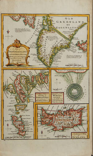
Bowen Grönland c. 1750
GREENLAND - ICELAND. BOWEN, Emanuel. A Map of Old Greenland or Öster Bygd & Wester Bygd... - A Map of the Islands of Ferro or Läs mer...
- 2020-09-09
- Stockholms Auktionsverk
- 1 600 SEK

Bowen map of the North Pole c. 1750
THE NORTH POLE. BOWEN, EMANUEL. A new & accurate map of the North Pole with all the countries hitherto discovered. Situated near or adjacent to Läs mer...
- 2019-11-14
- Stockholms Auktionsverk
- 1 000 SEK