
Janssonius´ map of the Baltics 1630
MAP OF THE BALTICS. JANSSONSIUS, J. Nova totius Livoniae accurata descriptio. Amsterdam, 1630-40. Some spotting, soiling and spotting to margins, tear to centrefold.
- 2018-01-24 00:00:00
- Stockholms Auktionsverk
- Länk till objektet
Slutpris:2 200 SEK
Avslutade auktioner liknande Janssonius´ map of the Baltics 1630

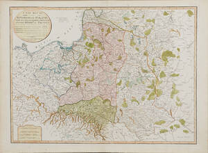
Map of Poland and the Baltics 2 maps
MAP OF POLAND AND THE BALTICS (2). MAYER, JOHANN TOBIAS. Mappa geographica regni Poloniae ex novissima quotquot sunt mappis specialibus composita... Nürnberg (Homann Heirs) 1773. Läs mer...
- 2018-03-14
- Stockholms Auktionsverk
- 2 400 SEK

Janssonius´ map of the Baltics 1630
MAP OF THE BALTICS. JANSSONSIUS, J. Nova totius Livoniae accurata descriptio. Amsterdam, 1630-40. Some minor tears and soiling to margins, some minor spotting to centrefold. Läs mer...
- 2015-02-19
- Stockholms Auktionsverk
- 3 000 SEK

Karta över Norden
Vägghängd karta över Norden. Kartografi, reproduktion & tryck Dr. Magnus Roth Mått: 210 x 155 cm Konditionsrapport: Märken, revor & bruksslitage, veck, inga övriga anmärkningar. Läs mer...
- 2022-12-01
- Norrlands Auktionsverk
- 550 SEK

Map of the Baltics with islands Ösel and Dagö 16...
SEA CHART OF THE BALTICS. Goos, P. (?), Pascaarte van Liiflandt ende Oost-Finlandt. Amsterdam c. 1660. Map cut to platemark, repaired tear to left part, Läs mer...
- 2017-06-09
- Stockholms Auktionsverk
- 3 800 SEK

Anson map of South America
MAP OF SOUTH AMERICA . ANSON, GEORGE. A chart of the southern part of South America : with the track of the Centurion from the Läs mer...
- 2020-09-20
- Stockholms Auktionsverk
- 2 400 SEK
Map of Poland 1799
MAP OF POLAND. A New Map Of The Kingdom of Poland with its Dismembered Provinces and the Kingdom of Prussia, London, Laurie & Whittle, 1799. Läs mer...
- 2020-09-20
- Stockholms Auktionsverk
- 1 600 SEK
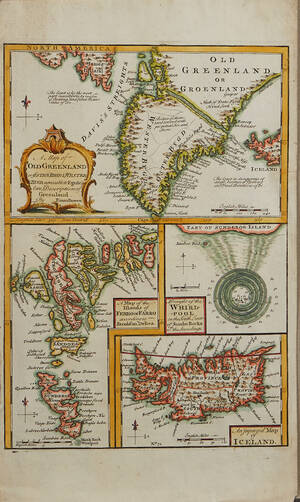
Bowen Grönland c. 1750
GREENLAND - ICELAND. BOWEN, Emanuel. A Map of Old Greenland or Öster Bygd & Wester Bygd... - A Map of the Islands of Ferro or Läs mer...
- 2020-09-09
- Stockholms Auktionsverk
- 1 600 SEK

Europakarta 1950-tal
Vägghängd karta över Europa. Kartografi, reproduktion & tryck: Karl Wenschow G.M.B.H Munchen. Mått: 213 x 176 cm Konditionsrapport: Märken, mindre revor & bruksslitage, Inga övriga Läs mer...
- 2022-09-01
- Norrlands Auktionsverk
- 500 SEK

South America map by Blome 1690
SCARE MAP OF SOUTH AMERICA. BLOME, RICHARD. A New Mapp of America Meridionale Designed by Monsieur Sanson Geographer to the French King... London, c. Läs mer...
- 2021-03-21
- Stockholms Auktionsverk
- 1 700 SEK

Bowen map of the North Pole c. 1750
THE NORTH POLE. BOWEN, EMANUEL. A new & accurate map of the North Pole with all the countries hitherto discovered. Situated near or adjacent to Läs mer...
- 2019-11-14
- Stockholms Auktionsverk
- 1 000 SEK